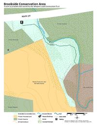
The bubbling Bread and Cheese Brook provides a peaceful soundtrack as you walk or fish at Brookside Conservation Area. This nine-acre Westport Land Conservation Trust property features a short but interesting streamside trail that’s a perfect escape for a breath of fresh air.
Features
Westport residents have used the waters of Bread and Cheese Brook, which flows from Fall River to the Westport River, for centuries. In the 18th century, Bread and Cheese Brook powered a grain mill and later a shingle and wagon spoke factory. More recently, diners enjoyed views of the tumbling stream from the windows of Brookside Restaurant, which once stood here. In 2009, the town and the Westport Land Conservation Trust forever protected this historically and ecologically significant property, creating the first public area to walk and fish on Bread and Cheese Brook. How did Bread and Cheese Brook get its unique name? Local legend says that in 1776, militia from the Head of Westport went to the brook’s edge to drink its water while they ate bread and cheese. Regardless of your meal of choice, Brookside Conservation Area still makes a nice spot for a picnic today!
Trails
Brookside Conservation Area features one short, out-and-back trail of about a quarter mile. The trail meanders alongside Bread and Cheese Brook and offers plenty of spots to stop and appreciate the view. You can get a glimpse into the property’s history about halfway down the trail, where the remnants of an antique granite bridge cross the brook. These stone blocks were one of the original stream crossings used by local farmers and mill workers. Though relatively flat, the trail is narrow and rocky in places. Wear sturdy footwear and watch your step around rocks and exposed roots.
Habitats & Wildlife
Brookside Conservation Area is part of a patchwork of preserved land at the head of the Westport River, including Forge Pond Conservation Area and Mill Pond Conservation Area. These reserves help to filter out pollutants and prevent them from flowing into the Westport River and ultimately Buzzards Bay. The water in this stretch of Bread and Cheese Brook runs dark with organic material picked up along its journey, moving quickly past rocks and large boulders on its way downstream. These waters and the surrounding woodlands are a haven for small animals like songbirds, butterflies, and dragonflies. If you sit quietly, you may even spot the property’s resident woodchuck, which has been spotted taking a dip in the brook on warm days.
Details & Amenities
Things to Do
Trail Maps
The bubbling Bread and Cheese Brook provides a peaceful soundtrack as you walk or fish at Brookside Conservation Area. This nine-acre Westport Land Conservation Trust property features a short but interesting streamside trail that’s a perfect escape for a breath of fresh air.
Features
Westport residents have used the waters of Bread and Cheese Brook, which flows from Fall River to the Westport River, for centuries. In the 18th century, Bread and Cheese Brook powered a grain mill and later a shingle and wagon spoke factory. More recently, diners enjoyed views of the tumbling stream from the windows of Brookside Restaurant, which once stood here. In 2009, the town and the Westport Land Conservation Trust forever protected this historically and ecologically significant property, creating the first public area to walk and fish on Bread and Cheese Brook. How did Bread and Cheese Brook get its unique name? Local legend says that in 1776, militia from the Head of Westport went to the brook’s edge to drink its water while they ate bread and cheese. Regardless of your meal of choice, Brookside Conservation Area still makes a nice spot for a picnic today!
Trails
Brookside Conservation Area features one short, out-and-back trail of about a quarter mile. The trail meanders alongside Bread and Cheese Brook and offers plenty of spots to stop and appreciate the view. You can get a glimpse into the property’s history about halfway down the trail, where the remnants of an antique granite bridge cross the brook. These stone blocks were one of the original stream crossings used by local farmers and mill workers. Though relatively flat, the trail is narrow and rocky in places. Wear sturdy footwear and watch your step around rocks and exposed roots.
Habitats & Wildlife
Brookside Conservation Area is part of a patchwork of preserved land at the head of the Westport River, including Forge Pond Conservation Area and Mill Pond Conservation Area. These reserves help to filter out pollutants and prevent them from flowing into the Westport River and ultimately Buzzards Bay. The water in this stretch of Bread and Cheese Brook runs dark with organic material picked up along its journey, moving quickly past rocks and large boulders on its way downstream. These waters and the surrounding woodlands are a haven for small animals like songbirds, butterflies, and dragonflies. If you sit quietly, you may even spot the property’s resident woodchuck, which has been spotted taking a dip in the brook on warm days.