Features
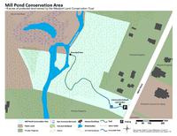
True to its name, Mill Pond Conservation Area features a breached dam from a mill that once stood here — one of the many sawmills, grain mills, and factories that made up the former industrial center here at the head of the Westport River. In contrast, today this property offers an escape from the hustle and bustle that surrounds it, offering riverside serenity that feels far from everyday life. Pull into the parking lot at Mill Pond Conservation Area, and you’ll immediately see the property’s most unique feature: an organic community orchard and garden. Volunteers with the Westport Land Conservation Trust planted frost-hardy apple, pear, and peach trees, raspberry bushes, and a rotating crop of vegetables and other edible plants that are open to all for picking during their seasons. There’s also a roadside stand with harvested produce for free pickup.
Trails
A firm crushed-rock path starts from the parking lot and leads through the orchard. In total, the trail is about a quarter-mile long. (Download trail map) The picturesque path through the orchard is handicap-accessible up to where it enters the woods. From there, the pine needle-coated trail slopes up and over a hill before leading down to the Noquochoke River. Here, the trail continues a short distance along the river down to the former stone dam — now breached so that the river and fish can flow through it unimpeded.
Habitats & Wildlife
The gardens and pathways of Mill Pond Conservation Area are planted with native flowers, which attract a wealth of pollinators to this property — from bees to monarch butterflies to jewel-colored hummingbirds. In the woods, look down for little milk snakes slithering through the underbrush, and up for the bright flash of the resident yellow warblers that nest on this property. Mill Pond Conservation Area is one of several conservation lands at the head of the Westport River’s East Branch, alongside Forge Pond Conservation Area and Brookside Conservation Area. These reserves help to filter out pollutants coming from the land, preventing pollution from flowing into the Westport River and onward to Buzzards Bay.
Details & Amenities
Things to Do
Trail Maps
Features
True to its name, Mill Pond Conservation Area features a breached dam from a mill that once stood here — one of the many sawmills, grain mills, and factories that made up the former industrial center here at the head of the Westport River. In contrast, today this property offers an escape from the hustle and bustle that surrounds it, offering riverside serenity that feels far from everyday life. Pull into the parking lot at Mill Pond Conservation Area, and you’ll immediately see the property’s most unique feature: an organic community orchard and garden. Volunteers with the Westport Land Conservation Trust planted frost-hardy apple, pear, and peach trees, raspberry bushes, and a rotating crop of vegetables and other edible plants that are open to all for picking during their seasons. There’s also a roadside stand with harvested produce for free pickup.
Trails
A firm crushed-rock path starts from the parking lot and leads through the orchard. In total, the trail is about a quarter-mile long. (Download trail map) The picturesque path through the orchard is handicap-accessible up to where it enters the woods. From there, the pine needle-coated trail slopes up and over a hill before leading down to the Noquochoke River. Here, the trail continues a short distance along the river down to the former stone dam — now breached so that the river and fish can flow through it unimpeded.
Habitats & Wildlife
The gardens and pathways of Mill Pond Conservation Area are planted with native flowers, which attract a wealth of pollinators to this property — from bees to monarch butterflies to jewel-colored hummingbirds. In the woods, look down for little milk snakes slithering through the underbrush, and up for the bright flash of the resident yellow warblers that nest on this property. Mill Pond Conservation Area is one of several conservation lands at the head of the Westport River’s East Branch, alongside Forge Pond Conservation Area and Brookside Conservation Area. These reserves help to filter out pollutants coming from the land, preventing pollution from flowing into the Westport River and onward to Buzzards Bay.