Explore miles of trails on foot, bike, or skis at this city-owned property, which is set among thousands of acres of protected land and protects clean drinking water for thousands of local residents.
Features
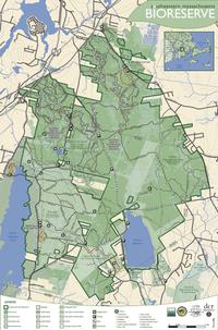
Discover old stone walls and quiet pine needle-carpeted paths at the Watuppa Reservation in Fall River.[/caption] Watuppa Reservation is the public portion of 8,500 acres of watershed lands around North Watuppa Pond, Fall River’s main source of public drinking water. This historically and ecologically important property is a serene destination that’s open for everybody to explore. (Because the Watuppa Reservation’s land protects clean drinking water, there is no swimming, wading, boating, dog-walking, or horseback riding allowed here.) Like neighboring Copicut Woods, Watuppa Reservation’s deep forests feel miles away from the city even though they’re located within Fall River. Hike, bike, or ski the reservation’s maze of paths, which connect with other properties in the Bioreserve. The city’s protected watershed lands also include the area around Copicut Reservoir, which is open to shore fishing.
Trails
Watuppa Reservation is home to several miles of wide, well-maintained trails that visitors of all ages can enjoy. Because many of the driving roads in the interior of the Bioreserve are rough and unmaintained, we recommend you approach the reservation from the south and use a map to guide your journey. (Download trail map) From the parking area on Blossom Road, you can explore the Homestead Loop: an easy one-mile trail that will give first-time visitors and beginner hikers a nice introduction to the reservation. This path is particularly fun for families with kids because the trails are marked with animal symbols! Looking for a little more adventure? Try the Corduroy Path, a swampy former farm road created by the farmer who once lived in the house that now serves as the reservation headquarters. Look out for notable sights such as King Philip’s Spring, a stone-lined stream that flows to North Watuppa Pond. The Corduroy Path links with many other trails that weave for miles through the reservation and lead you to other parts of the Bioreserve. You’ll find another self-guided interpretive trail at the Tattapanum Trail, located on the northwest edge of North Watuppa Pond. (Access this trail by driving around the pond to Wilson Road, off Route 24.) This short loop trail circles through a spruce grove and offers views of the pond – known as a great place to spot bald eagles!
Habitats & Wildlife
The watershed lands around North Watuppa Pond and the Copicut Reservior act as a protective buffer for these public drinking water supply areas. The ponds also connect to both Buzzards Bay and Narragansett Bay. Watuppa Reservation is part of the larger Southeastern Massachusetts Bioreserve, one of the largest unfragmented forests in eastern Massachusetts. As part of the Bioreserve (along with neighboring Copicut Woods, Freetown-Fall River State Forest, and Copicut Wildlife Management Area), Watuppa Reservation protects a special ecosystem that provides habitat for countless wildlife species. Like other parts of the Bioreserve, Watuppa Reservation is home to a rare Atlantic white cedar swamp, where frogs and salamanders breed in spring.
Details & Amenities
Things to Do
Trail Maps
Image Gallery

Explore miles of trails on foot, bike, or skis at this city-owned property, which is set among thousands of acres of protected land and protects clean drinking water for thousands of local residents.
Features
Discover old stone walls and quiet pine needle-carpeted paths at the Watuppa Reservation in Fall River.[/caption] Watuppa Reservation is the public portion of 8,500 acres of watershed lands around North Watuppa Pond, Fall River’s main source of public drinking water. This historically and ecologically important property is a serene destination that’s open for everybody to explore. (Because the Watuppa Reservation’s land protects clean drinking water, there is no swimming, wading, boating, dog-walking, or horseback riding allowed here.) Like neighboring Copicut Woods, Watuppa Reservation’s deep forests feel miles away from the city even though they’re located within Fall River. Hike, bike, or ski the reservation’s maze of paths, which connect with other properties in the Bioreserve. The city’s protected watershed lands also include the area around Copicut Reservoir, which is open to shore fishing.
Trails
Watuppa Reservation is home to several miles of wide, well-maintained trails that visitors of all ages can enjoy. Because many of the driving roads in the interior of the Bioreserve are rough and unmaintained, we recommend you approach the reservation from the south and use a map to guide your journey. (Download trail map) From the parking area on Blossom Road, you can explore the Homestead Loop: an easy one-mile trail that will give first-time visitors and beginner hikers a nice introduction to the reservation. This path is particularly fun for families with kids because the trails are marked with animal symbols! Looking for a little more adventure? Try the Corduroy Path, a swampy former farm road created by the farmer who once lived in the house that now serves as the reservation headquarters. Look out for notable sights such as King Philip’s Spring, a stone-lined stream that flows to North Watuppa Pond. The Corduroy Path links with many other trails that weave for miles through the reservation and lead you to other parts of the Bioreserve. You’ll find another self-guided interpretive trail at the Tattapanum Trail, located on the northwest edge of North Watuppa Pond. (Access this trail by driving around the pond to Wilson Road, off Route 24.) This short loop trail circles through a spruce grove and offers views of the pond – known as a great place to spot bald eagles!
Habitats & Wildlife
The watershed lands around North Watuppa Pond and the Copicut Reservior act as a protective buffer for these public drinking water supply areas. The ponds also connect to both Buzzards Bay and Narragansett Bay. Watuppa Reservation is part of the larger Southeastern Massachusetts Bioreserve, one of the largest unfragmented forests in eastern Massachusetts. As part of the Bioreserve (along with neighboring Copicut Woods, Freetown-Fall River State Forest, and Copicut Wildlife Management Area), Watuppa Reservation protects a special ecosystem that provides habitat for countless wildlife species. Like other parts of the Bioreserve, Watuppa Reservation is home to a rare Atlantic white cedar swamp, where frogs and salamanders breed in spring.