Take in some of the most breathtaking views on Martha’s Vineyard from the Aquinnah Headlands Preserve, located above and around the Gay Head Cliffs. Gently sloping trails lead you through coastal thicket above the cliffs and to the beach below, providing stunning views of the iconic Gay Head Lighthouse. This property is jointly protected by the Martha’s Vineyard Land Bank Commission, Sheriff’s Meadow Foundation, and the town of Aquinnah.
Features
Aquinnah Headlands Preserve sits at the northwestern corner of Martha’s Vineyard, at the outer edge of southern Vineyard Sound. Exploring this preserve is the best way to view Gay Head Cliffs, the striking line of bluffs that complete this corner of the island. This stretch of colorful sandstone and clay cliffs tower 130 feet above crashing waves, watched over by the stately Gay Head Lighthouse. It’s no surprise that the Gay Head Cliffs — owned and protected by the Aquinnah Wampanoag Tribe — are designated a National Natural Landmark by the National Parks Service, or that they have been called the most beautiful place in Massachusetts. Two easy-to-explore trails provide access to the upland surrounding the cliffs and lead down to the fine sandy shores of Moshup Beach, where you can walk miles of coastline beneath the cliffs.
Trails
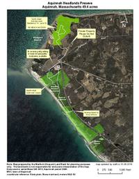
The upper portion of Aquinnah Headlands Preserve is a seasonal trail called North Head, a short loop through wildflower-filled coastal brush above the Gay Head Cliffs. To reach the trailhead, walk from Lighthouse Road down the driveway of the Outermost Inn; you’ll see the trail to the far left of the inn. North Head trail offers views of the Gay Head Lighthouse at nearly every point of the trail, as well as an incredible panorama of Vineyard Sound and the Elizabeth Islands at its peak. This trail is open from September 15 to June 15. (Download trail map) The South Head Loop, open year-round, can be accessed from the back of the parking lot on Aquinnah Circle, or next to the Aquinnah Cultural Center. The trail is wide and gently sloping, transitioning from hard-packed dirt and wood chips to rocks and sand at the coast, making it easy for explorers of all ages to enjoy. Follow the trail down to the shoreline to continue your exploration on the coast at Moshup Beach.
Habitats & Wildlife
The sandstones and clays of Gay Head Cliffs are ancient, laid down during the age of the dinosaurs and later pushed up by passing glaciers. As you appreciate the swirls of deep purple, orange, brick red, and mustard yellow on the cliffs’ surface, you’re looking back in time, at the remnants of swamps and river deltas that thrived when the climate here was hot and tropical. The beach and coastal thicket around these ancient cliffs are also home to a variety of modern-day life. The brush around the trails of Aquinnah Headlands grow thick with native goldenrod and purple thistle in the fall, attracting monarch butterflies on their migration south. This corner of the island is also a hotspot for bird activity, as it is a perfect stopover for birds migrating along the east coast. Seabirds and shorebirds flock overhead and in the waters offshore, from common gulls to overwintering ducks, but unusual songbirds and tropical species might also be spotted during fall and spring migration or after storms.
Details & Amenities
Trail Maps
Image Gallery


Take in some of the most breathtaking views on Martha’s Vineyard from the Aquinnah Headlands Preserve, located above and around the Gay Head Cliffs. Gently sloping trails lead you through coastal thicket above the cliffs and to the beach below, providing stunning views of the iconic Gay Head Lighthouse. This property is jointly protected by the Martha’s Vineyard Land Bank Commission, Sheriff’s Meadow Foundation, and the town of Aquinnah.
Features
Aquinnah Headlands Preserve sits at the northwestern corner of Martha’s Vineyard, at the outer edge of southern Vineyard Sound. Exploring this preserve is the best way to view Gay Head Cliffs, the striking line of bluffs that complete this corner of the island. This stretch of colorful sandstone and clay cliffs tower 130 feet above crashing waves, watched over by the stately Gay Head Lighthouse. It’s no surprise that the Gay Head Cliffs — owned and protected by the Aquinnah Wampanoag Tribe — are designated a National Natural Landmark by the National Parks Service, or that they have been called the most beautiful place in Massachusetts. Two easy-to-explore trails provide access to the upland surrounding the cliffs and lead down to the fine sandy shores of Moshup Beach, where you can walk miles of coastline beneath the cliffs.
Trails
The upper portion of Aquinnah Headlands Preserve is a seasonal trail called North Head, a short loop through wildflower-filled coastal brush above the Gay Head Cliffs. To reach the trailhead, walk from Lighthouse Road down the driveway of the Outermost Inn; you’ll see the trail to the far left of the inn. North Head trail offers views of the Gay Head Lighthouse at nearly every point of the trail, as well as an incredible panorama of Vineyard Sound and the Elizabeth Islands at its peak. This trail is open from September 15 to June 15. (Download trail map) The South Head Loop, open year-round, can be accessed from the back of the parking lot on Aquinnah Circle, or next to the Aquinnah Cultural Center. The trail is wide and gently sloping, transitioning from hard-packed dirt and wood chips to rocks and sand at the coast, making it easy for explorers of all ages to enjoy. Follow the trail down to the shoreline to continue your exploration on the coast at Moshup Beach.
Habitats & Wildlife
The sandstones and clays of Gay Head Cliffs are ancient, laid down during the age of the dinosaurs and later pushed up by passing glaciers. As you appreciate the swirls of deep purple, orange, brick red, and mustard yellow on the cliffs’ surface, you’re looking back in time, at the remnants of swamps and river deltas that thrived when the climate here was hot and tropical. The beach and coastal thicket around these ancient cliffs are also home to a variety of modern-day life. The brush around the trails of Aquinnah Headlands grow thick with native goldenrod and purple thistle in the fall, attracting monarch butterflies on their migration south. This corner of the island is also a hotspot for bird activity, as it is a perfect stopover for birds migrating along the east coast. Seabirds and shorebirds flock overhead and in the waters offshore, from common gulls to overwintering ducks, but unusual songbirds and tropical species might also be spotted during fall and spring migration or after storms.