Features
Menemsha Hills provides one of the longest walks available on the shores of Vineyard Sound. For gorgeous coastal views, hike to the top of Prospect Hill, which at 308 feet is only three feet shy of being the Vineyard’s highest peak. (That honor goes to 311-foot Peaked Hill, located a mile southeast.) Or head down to the shoreline to explore dramatic cliffs and beaches covered with erratics, boulders dropped off by glaciers during the last Ice Age. Anglers willing to carry in a pole will find great surfcasting from the deserted shoreline, while birders will love the variety of winged visitors that ride the breezes along these cliffs. Menemsha Hills was once known for the brick ovens stationed throughout the area, which fired the island’s grayish clay into 800,000 lobster-red bricks per year. But locals have always favored this land for a brisk walk, following former deer and cattle trails through the woods to the beach. Although Menemsha Hills can now be navigated by The Trustees’ official marked trails, these glacial hills still retain their wild, windswept charm.
Trails
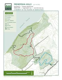
Menemsha Hills’ three-mile trail network contains two connected loops that lead you up and down rolling hills. Although these hills are gentle enough for hikers of all levels, be mindful that the property slopes downward toward the coast. As a result, you may find yourself working a bit harder on the walk back than on the trip in! (Download trail map) If you’re looking for a short, easy walk, we recommend the first loop from the parking area, called the Harris Loop. The Harris Loop has two half-mile legs broken up by gorgeous views. Stop at the top of Prospect Hill for a picnic overlooking the deep blue of Vineyard Sound and the stunning sweep of the Elizabeth Islands. Look east for the remnants of one of Menemsha Hills’ brick chimneys poking out over the scrubby trees, or west to spot the red and white flash of Gay Head Light. Looking for a longer hike, or seeking coastal solitude? Continue onward to the 1.5-mile Nashawakemuck Loop. The eastern branch of this loop is slightly shorter, with a scenic western-facing overlook at its halfway point. The two sides meet up just before a wooden platform that provides dramatic vistas of the Vineyard’s cliff-lined eastern end. The trail ends in a staircase that leads down to the rocky beach.
Habitats & Wildlife
A walk at Menemsha Hills delivers the unique experience of passing through changing habitats as you approach the coast. The trail starts among woodland groves and passes through a mix of forest and wetland. In the spring and summer, listen here for the knocking of woodpeckers pursuing their lunch, and pause by small ponds and vernal pools to look for wriggling tadpoles, salamanders, and frogs. Nearer to the ocean, trees like oak, red maple, and beech will give way to scrubby pitch pines, beach plum, and huckleberry and bayberry bushes among the dunes. Menemsha’s high scenic overlooks are an excellent place to look for birds. Hunting hawks and gulls are a common sight riding the thermals that rise up these cliffs. However, the Vineyard’s position along the Atlantic Flyway means that you might spot some more unusual birds as they migrate along the coast. Look for bobbing scoters with their knobby orange beaks, and acrobatic diving white gannets with bright blue-rimmed eyes.
Details & Amenities
Things to Do
Trail Maps
Image Gallery


Features
Menemsha Hills provides one of the longest walks available on the shores of Vineyard Sound. For gorgeous coastal views, hike to the top of Prospect Hill, which at 308 feet is only three feet shy of being the Vineyard’s highest peak. (That honor goes to 311-foot Peaked Hill, located a mile southeast.) Or head down to the shoreline to explore dramatic cliffs and beaches covered with erratics, boulders dropped off by glaciers during the last Ice Age. Anglers willing to carry in a pole will find great surfcasting from the deserted shoreline, while birders will love the variety of winged visitors that ride the breezes along these cliffs. Menemsha Hills was once known for the brick ovens stationed throughout the area, which fired the island’s grayish clay into 800,000 lobster-red bricks per year. But locals have always favored this land for a brisk walk, following former deer and cattle trails through the woods to the beach. Although Menemsha Hills can now be navigated by The Trustees’ official marked trails, these glacial hills still retain their wild, windswept charm.
Trails
Menemsha Hills’ three-mile trail network contains two connected loops that lead you up and down rolling hills. Although these hills are gentle enough for hikers of all levels, be mindful that the property slopes downward toward the coast. As a result, you may find yourself working a bit harder on the walk back than on the trip in! (Download trail map) If you’re looking for a short, easy walk, we recommend the first loop from the parking area, called the Harris Loop. The Harris Loop has two half-mile legs broken up by gorgeous views. Stop at the top of Prospect Hill for a picnic overlooking the deep blue of Vineyard Sound and the stunning sweep of the Elizabeth Islands. Look east for the remnants of one of Menemsha Hills’ brick chimneys poking out over the scrubby trees, or west to spot the red and white flash of Gay Head Light. Looking for a longer hike, or seeking coastal solitude? Continue onward to the 1.5-mile Nashawakemuck Loop. The eastern branch of this loop is slightly shorter, with a scenic western-facing overlook at its halfway point. The two sides meet up just before a wooden platform that provides dramatic vistas of the Vineyard’s cliff-lined eastern end. The trail ends in a staircase that leads down to the rocky beach.
Habitats & Wildlife
A walk at Menemsha Hills delivers the unique experience of passing through changing habitats as you approach the coast. The trail starts among woodland groves and passes through a mix of forest and wetland. In the spring and summer, listen here for the knocking of woodpeckers pursuing their lunch, and pause by small ponds and vernal pools to look for wriggling tadpoles, salamanders, and frogs. Nearer to the ocean, trees like oak, red maple, and beech will give way to scrubby pitch pines, beach plum, and huckleberry and bayberry bushes among the dunes. Menemsha’s high scenic overlooks are an excellent place to look for birds. Hunting hawks and gulls are a common sight riding the thermals that rise up these cliffs. However, the Vineyard’s position along the Atlantic Flyway means that you might spot some more unusual birds as they migrate along the coast. Look for bobbing scoters with their knobby orange beaks, and acrobatic diving white gannets with bright blue-rimmed eyes.