Protected by several local groups and managed by the Buzzards Bay Coalition, Mass Audubon, Wildlands Trust, and Wareham Land Trust, this critical coastal habitat is a great place to discover seabirds and woodland animals as you take in the natural beauty of upper Buzzards Bay. Learn about efforts to improve the habitats and trails at Marks Cove here.
Features
Marks Cove Conservation Area features a view into the coastal habitats of the upper portion of Buzzards Bay, where sandy forests intermingle with rich salt marshes. Walk the quiet trails here to discover these woods and wetlands along the edge of the property’s namesake cove. This property is preserved in parcels owned by the Buzzards Bay Coalition, Wareham Land Trust, Wildlands Trust, Mass Audubon, and the town of Wareham, creating a quilt of 118 acres of protected land that will conserve these important coastal habitats for generations to come.
Trails
The trails at Marks Cove Conservation Area cover the property’s diverse habitats within three relatively short loops, making this a perfect place for an interesting and relaxing walk. (Download trail map) The trails begin at the end of Nicholas Drive, just beyond the metal gate. You’ll pass between two bright blue freshwater ponds onto the half-mile Cranberry Bog Loop, the first of the three trails. As its name suggests, this trail circles a retired cranberry bog that is reverting back to natural wetlands. Take your time as you look for wildlife among the waving marsh grasses that grow tall along the trail. From the Cranberry Bog Loop, you have two choices of where to go next. The Gleason Loop follows a power line corridor along the western edge of the property to the head of Marks Cove. Choose this mile-long trail if you want to watch for birds hunting in the cove’s upper marshes. The 0.9-mile Box Turtle Loop, which runs through the center of the property, consists of two overlapping loops through the woods. The trail ends with a gorgeous view where the lower marshes unfold into the cove’s open water. (This loop intersects a dirt road that leads onto private property, so be sure to carefully follow the orange blazes marking the trail as you walk.)
Habitats & Wildlife
Although it’s just a stone’s throw from residential homes, Marks Cove Conservation Area is a fantastic place to seek out wildlife. Birds flock here year-round; look out for red-winged blackbirds clinging acrobatically to bog grasses and oystercatchers with their long, bright orange bills down by the salt marsh in summer. Marks Cove is also a productive habitat for shellfish: its waters and shores are rich with quahogs, bay scallops, oysters, and soft-shelled clams. These diverse forests and wetlands along Marks Cove have been recognized as priority habitat for rare and endangered species like the Eastern box turtle by the Natural Heritage and Endangered Species Program. Because this area is susceptible to coastal flooding, preserving it allows critical coastal habitat, like salt marshes, room to migrate inland with storms and rising sea levels.
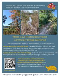
Improving Trails & Habitats
Efforts are currently underway by the conservation area partners to improve the trails and habitats here. Restoration will improve the resilience of this land to climate change and increase its value as a community resource. With funding from NOAA, the Coalition together with our partners at Mass Audubon, Wareham Land Trust and Wildlands Trust are working with an engineering firm on developing the vision for the improved site. We want your input.
Details & Amenities
Trail Maps
Image Gallery


Protected by several local groups and managed by the Buzzards Bay Coalition, Mass Audubon, Wildlands Trust, and Wareham Land Trust, this critical coastal habitat is a great place to discover seabirds and woodland animals as you take in the natural beauty of upper Buzzards Bay. Learn about efforts to improve the habitats and trails at Marks Cove here.
Features
Marks Cove Conservation Area features a view into the coastal habitats of the upper portion of Buzzards Bay, where sandy forests intermingle with rich salt marshes. Walk the quiet trails here to discover these woods and wetlands along the edge of the property’s namesake cove. This property is preserved in parcels owned by the Buzzards Bay Coalition, Wareham Land Trust, Wildlands Trust, Mass Audubon, and the town of Wareham, creating a quilt of 118 acres of protected land that will conserve these important coastal habitats for generations to come.
Trails
The trails at Marks Cove Conservation Area cover the property’s diverse habitats within three relatively short loops, making this a perfect place for an interesting and relaxing walk. (Download trail map) The trails begin at the end of Nicholas Drive, just beyond the metal gate. You’ll pass between two bright blue freshwater ponds onto the half-mile Cranberry Bog Loop, the first of the three trails. As its name suggests, this trail circles a retired cranberry bog that is reverting back to natural wetlands. Take your time as you look for wildlife among the waving marsh grasses that grow tall along the trail. From the Cranberry Bog Loop, you have two choices of where to go next. The Gleason Loop follows a power line corridor along the western edge of the property to the head of Marks Cove. Choose this mile-long trail if you want to watch for birds hunting in the cove’s upper marshes. The 0.9-mile Box Turtle Loop, which runs through the center of the property, consists of two overlapping loops through the woods. The trail ends with a gorgeous view where the lower marshes unfold into the cove’s open water. (This loop intersects a dirt road that leads onto private property, so be sure to carefully follow the orange blazes marking the trail as you walk.)
Habitats & Wildlife
Although it’s just a stone’s throw from residential homes, Marks Cove Conservation Area is a fantastic place to seek out wildlife. Birds flock here year-round; look out for red-winged blackbirds clinging acrobatically to bog grasses and oystercatchers with their long, bright orange bills down by the salt marsh in summer. Marks Cove is also a productive habitat for shellfish: its waters and shores are rich with quahogs, bay scallops, oysters, and soft-shelled clams. These diverse forests and wetlands along Marks Cove have been recognized as priority habitat for rare and endangered species like the Eastern box turtle by the Natural Heritage and Endangered Species Program. Because this area is susceptible to coastal flooding, preserving it allows critical coastal habitat, like salt marshes, room to migrate inland with storms and rising sea levels.
Improving Trails & Habitats
Efforts are currently underway by the conservation area partners to improve the trails and habitats here. Restoration will improve the resilience of this land to climate change and increase its value as a community resource. With funding from NOAA, the Coalition together with our partners at Mass Audubon, Wareham Land Trust and Wildlands Trust are working with an engineering firm on developing the vision for the improved site. We want your input.