Dunham’s Brook Conservation Area hosts many distinct environments in one location. One of the largest public conservation areas in Westport, this 159-acre Westport Land Conservation Trust property protects an important source of fresh water to the Westport River.
Features
Dunham’s Brook Conservation Area showcases Westport’s characteristically rich combination of wetlands, forests, and agriculture. You can walk through the tall stalks of a summer corn field, and over forest footbridges crossing picturesque Dunham’s Brook. In the spring, vernal pools form among the wooded wetlands at the edge of the property, and the air rings with the chirp of mating frogs.
Trails
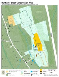
Dunham’s Brook Conservation Area features three miles of trails. Marked with circular colored signs, these looping trails offer a variety of options as they wind through the property’s diverse views. (Download trail map) The orange trail, which starts from the parking lot, crosses a small meadow before entering the forest. It traverses Dunham’s Brook and a winding boardwalk above marshy undergrowth before sloping upward to a set of stairs. Head south past the stairs to continue on the orange trail in a loop through the forest and wooded wetlands. To reach the corn field, climb up the stairs to start on the blue trail. This trail climbs a gentle ridge as you enter the corn field, forming a loop, with the remnants of an old corn silo along its western branch. If you’d like to walk farther, branch off of the blue loop onto the green trail to continue northwest through the corn field. The green trail ends with a loop through oak and holly woodlands — a good place to listen for songbirds in the spring.
Habitats & Wildlife
Dunham’s Brook empties into the West Branch of the Westport River. Preserved lands like Dunham’s Brook Conservation Area shelter this important source of clean water from pollution. This land also protects valuable habitats for deer, birds, and wetland animals like frogs and salamanders, which flourish in its wetlands and vernal pools. The state Division of Fisheries and Wildlife has identified a breeding population of native sea-run brook trout, or “salters,” in the portion of Dunham’s Brook south of Main Road. The Westport Land Conservation Trust is replacing two roadway culverts with footbridges to improve passage for salters and allow them to return to the upper reaches of Dunham’s Brook.
Details & Amenities
Things to Do
Trail Maps
Image Gallery

Dunham’s Brook Conservation Area hosts many distinct environments in one location. One of the largest public conservation areas in Westport, this 159-acre Westport Land Conservation Trust property protects an important source of fresh water to the Westport River.
Features
Dunham’s Brook Conservation Area showcases Westport’s characteristically rich combination of wetlands, forests, and agriculture. You can walk through the tall stalks of a summer corn field, and over forest footbridges crossing picturesque Dunham’s Brook. In the spring, vernal pools form among the wooded wetlands at the edge of the property, and the air rings with the chirp of mating frogs.
Trails
Dunham’s Brook Conservation Area features three miles of trails. Marked with circular colored signs, these looping trails offer a variety of options as they wind through the property’s diverse views. (Download trail map) The orange trail, which starts from the parking lot, crosses a small meadow before entering the forest. It traverses Dunham’s Brook and a winding boardwalk above marshy undergrowth before sloping upward to a set of stairs. Head south past the stairs to continue on the orange trail in a loop through the forest and wooded wetlands. To reach the corn field, climb up the stairs to start on the blue trail. This trail climbs a gentle ridge as you enter the corn field, forming a loop, with the remnants of an old corn silo along its western branch. If you’d like to walk farther, branch off of the blue loop onto the green trail to continue northwest through the corn field. The green trail ends with a loop through oak and holly woodlands — a good place to listen for songbirds in the spring.
Habitats & Wildlife
Dunham’s Brook empties into the West Branch of the Westport River. Preserved lands like Dunham’s Brook Conservation Area shelter this important source of clean water from pollution. This land also protects valuable habitats for deer, birds, and wetland animals like frogs and salamanders, which flourish in its wetlands and vernal pools. The state Division of Fisheries and Wildlife has identified a breeding population of native sea-run brook trout, or “salters,” in the portion of Dunham’s Brook south of Main Road. The Westport Land Conservation Trust is replacing two roadway culverts with footbridges to improve passage for salters and allow them to return to the upper reaches of Dunham’s Brook.