Scientists work to solve Westport River’s eroding salt marsh mystery
A new research project brings together scientists from across Buzzards Bay to understand why salt marshes on the Westport River are collapsing.

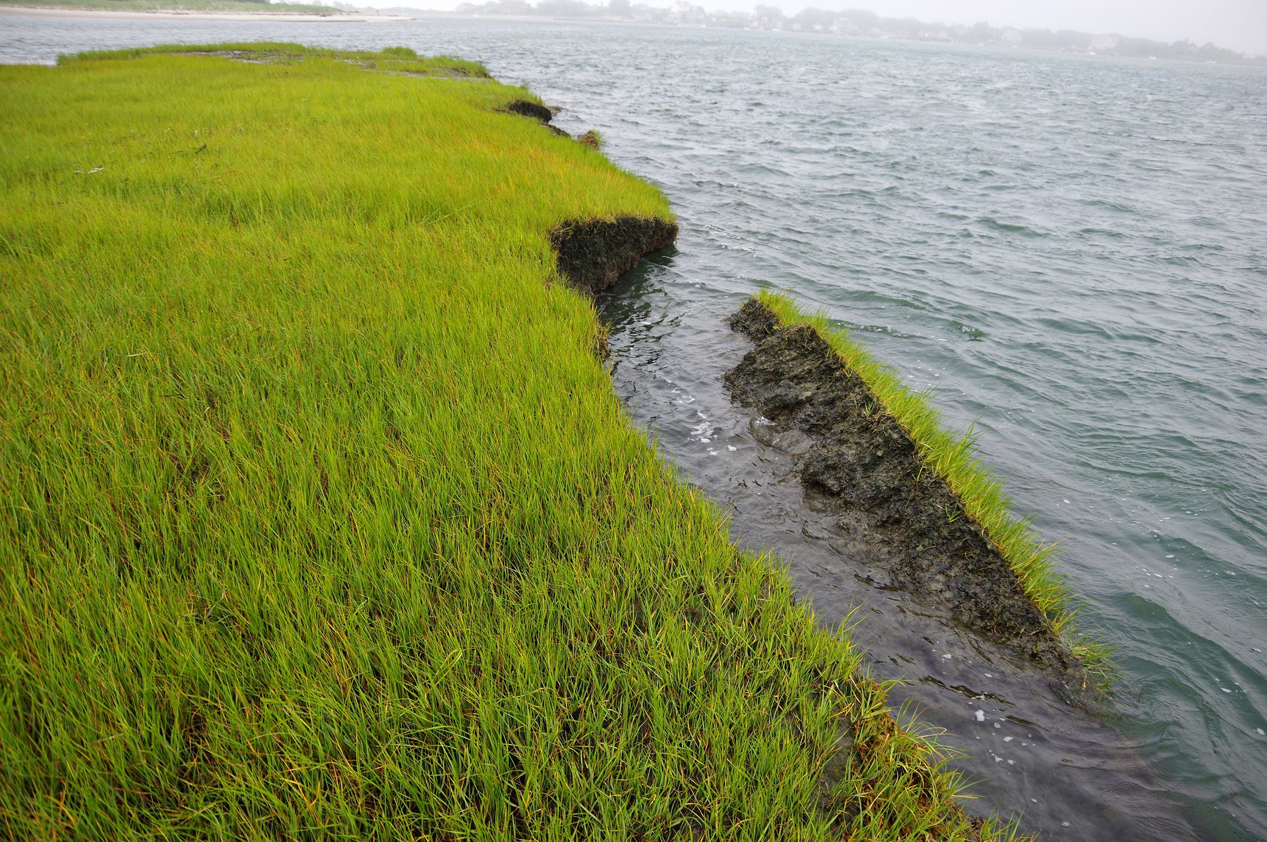
A few years ago, Jack Reynolds noticed that salt marshes on the Westport River were collapsing. “Big chunks of the marshes were falling in,” he remembered.
Reynolds used to fish on the Westport River back in the 1970s each spring, when young striped bass move into the estuary to feed among the river’s rich salt marshes. He would use the marshes as markers to remember the best spots to troll for bass.
“I noticed the marshes were not the same as they were back then,” Reynolds said. “I thought, ‘There’s something going on here that’s just not right.’”
Reynolds published a column about his findings in a newsletter for the Westport Fishermen’s Association, which he serves as president. That’s when he heard from others on the river who said they had noticed the erosion as well.
Now, a new research project is bringing together scientists from across Buzzards Bay to find an answer to the eroding salt marsh mystery and help protect the future of the Westport River’s salt marshes.
Why are the Westport River’s salt marshes eroding?
When Reynolds first realized that the Westport River’s marshes were collapsing, he did some research and came upon a study about salt marsh erosion in the Plum Island estuary, just north of Boston.In this study, led by the Marine Biological Laboratory Ecosystems Center scientist Dr. Linda Deegan and published in 2012, scientists discovered that nutrient pollution can cause salt marshes to collapse over time.
[youtube]https://www.youtube.com/watch?v=eP3hRkX03Q8[/youtube]
“When I saw her study and the results of introducing nutrients to an otherwise-untouched marsh, I said, ‘That’s exactly what’s happening here,’” Reynolds said.
The Westport River is one of many waterways around Buzzards Bay suffering from nitrogen pollution, the greatest threat to the Bay’s long-term health. Nitrogen pollution comes mainly from septic systems and wastewater treatment plants, as well as lawns, farms, and roads. The upper and inner sections of the East Branch of the Westport River have some of the lowest health scores on all of Buzzards Bay, indicating severe nitrogen pollution and poor health.
Salt marshes are powerful pollution filters that absorb nutrients such as nitrogen from stormwater runoff. Until the Plum Island study, scientists believed that marshes had an unlimited capacity to remove nutrients. But Deegan’s study showed for the first time that nutrient pollution can eventually harm these important habitats – and with salt marshes falling apart up and down the East Coast, there’s potential that this problem could be widespread.
The idea that nitrogen pollution might be causing salt marsh erosion in Westport intrigued Dr. Christopher Neill, senior scientist with the Woods Hole Research Center and chair of the Coalition’s Science Advisory Committee. “We thought it would be interesting to test that idea in the Westport River because we have long-term data on nitrogen concentrations in the river.”
Now in its 25th year, the Coalition’s Baywatchers program collects data on nitrogen, oxygen, water clarity, and other important indicators of the health of Buzzards Bay’s harbors, coves, and rivers. “There aren’t many other places where we can look at long-term data like that,” Neill said.
Dr. Rachel Jakuba, science director at the Coalition, noted that there are also other reasons why the river’s salt marshes could be degrading. Nitrogen pollution is one possible cause, but sea level rise caused by climate change is another potential culprit. “If it’s nutrients, we would expect [erosion] to be worse farther up the river. If it’s sea level rise, we would expect it to be worse near the river’s mouth,” where wave action is stronger.
Neill echoed Jakuba’s thoughts on the possible causes of salt marsh losses in the Westport River. For instance, crabs and other marsh-dwelling invertebrates that graze on marsh grasses could also play a role. “The answer may turn out to be that the causes are different even in different parts of the river,” he said.
How are scientists working to uncover the cause of salt marsh erosion on the Westport River?
The Coalition, in partnership with the Woods Hole Research Center, the Marine Biological Laboratory, the Buzzards Bay National Estuary Program, and the Westport Fishermen’s Association, set out to test this theory. Through a project taking place this summer, scientists are working to figure out whether nitrogen pollution is the culprit – or if other factors are causing the salt marsh erosion.
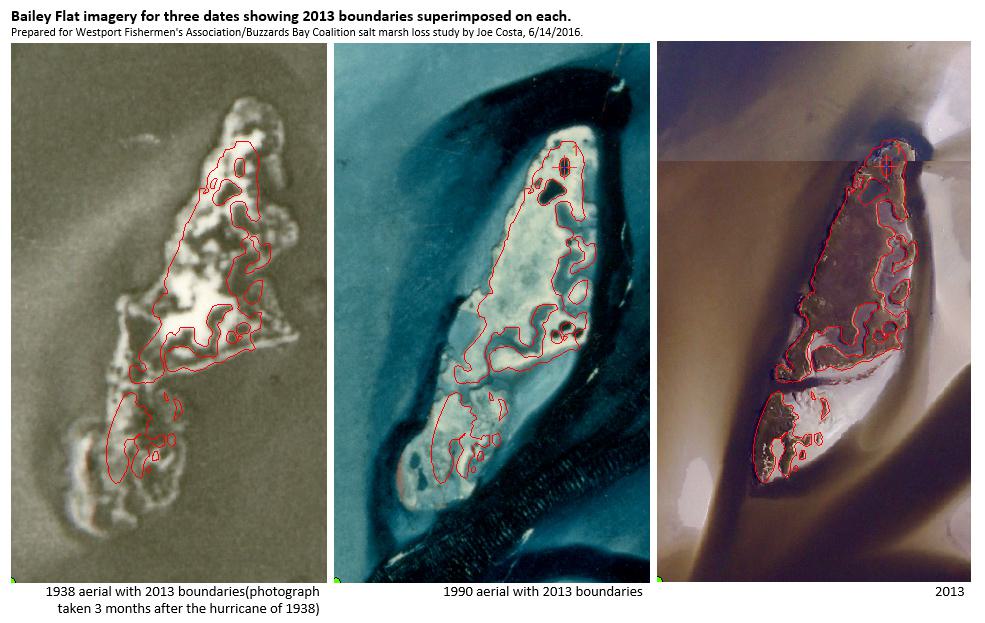
With support from the Westport Fishermen’s Association, the Coalition hired a summer intern, Molly Weiner, to examine historical aerial photos of the Westport River that date back to 1938. Through these photos, Weiner and Dr. Joe Costa, executive director of the Buzzards Bay National Estuary Program, are “going back in time” to look at how the river’s salt marshes have changed over the decades.
“You can see pannes (small pools of water in a salt marsh) growing over time, and you can see the boundaries of salt marsh islands receding over time,” said Costa. “I think we’re looking at marsh changes at a level of detail that few people have.”
Weiner and Costa are using the photos to create a “storybook” of detailed maps that show how the marshes have changed over the past century. The photos can also reveal patterns, according to Jakuba. “From the aerial images, we can get a sense of whether the change has been constant and slow, or if it’s been accelerating over the past few years,” she said.
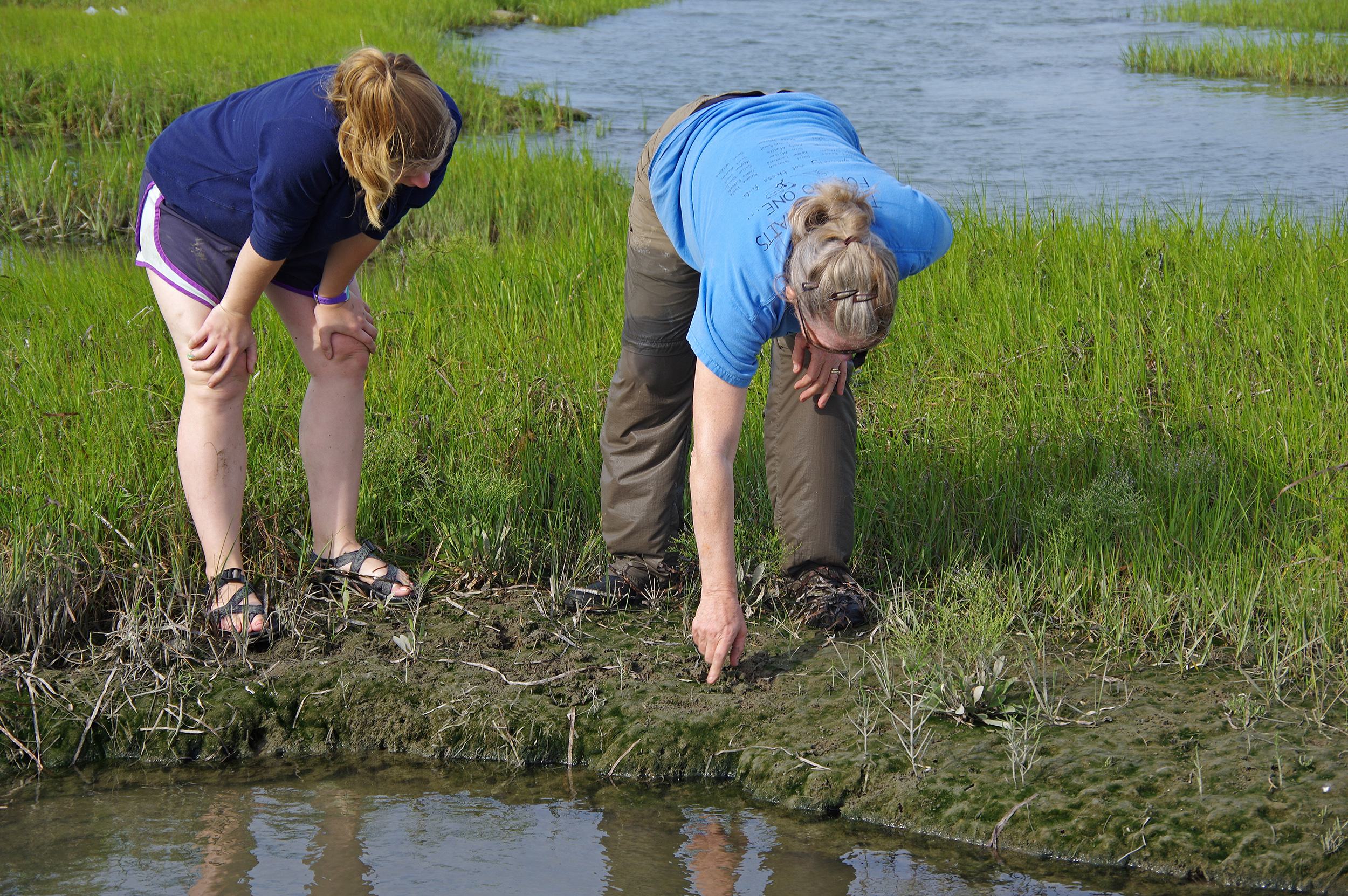
The team is also conducting field work to test the nitrogen pollution question. Deegan, the scientist who led the Plum Island study, is overseeing Weiner’s efforts to collect samples of salt marsh grasses from six different sites along the West Branch of the Westport River. “The aerial images give us an idea of where to sample on the ground,” Weiner said. “We’re picking sites that look consistent over time and ones that look like they’ve changed.”
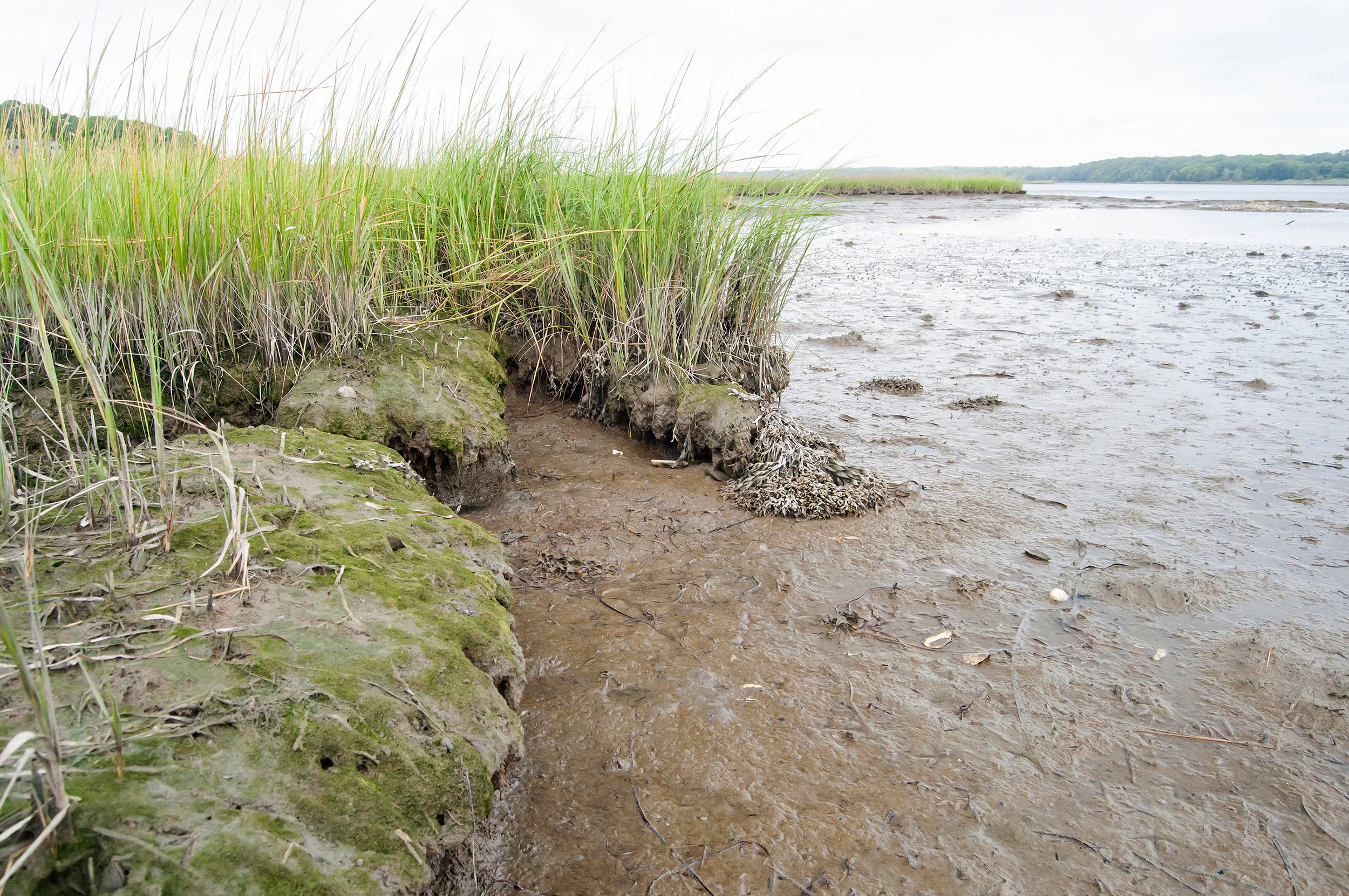
At each location, Weiner takes several square-foot samples of plants growing along the edges of the marsh. She also takes a core sample of mud and plant roots about a foot deep into the marsh. It’s a way to examine how dense the marsh’s root systems are – an important clue that can signal whether marshes are being affected by nitrogen pollution.
“Healthy marshes have dense roots below ground,” explained Jakuba. “But when there’s nitrogen pollution, roots don’t need to grow so deep, which can cause the marshes to cave in. That’s the main theory we’re testing with this field work.”
The Plum Island study revealed these harmful effects of nitrogen pollution on salt marshes. At first, nutrient pollution acts as fertilizer, causing marsh grasses to grow greener and taller. But these taller, nitrogen-enriched grasses produce fewer roots and rhizomes, which help stabilize the edge of a marsh. Eventually, the poorly rooted grasses fall over, causing cracks in the marsh.
“The way the marsh is collapsing [on the Westport River] looks similar to Plum Island in some places, but different in others,” said Neill. “This is a very interesting opportunity to look at what factors are leading to marsh loss.”
The Westport River study is expected to be completed in October. Although it likely won’t reveal all the answers to scientists’ questions, it will provide important information that could help explain salt marsh losses in the river and in other places around Buzzards Bay, and even up and down the East Coast.
For Reynolds and others who love the Westport River, this study may offer clues that could help save the marshes where they go fishing, quahogging, boating, and paddling. “This study may not provide a cure, but it may give us a little bit of fodder to go for legislation and help in reducing nutrients,” he said. “Otherwise, I can see in the future, the marshes will be gone.”


