Features
Kettle Holes Conservation Area sits on Falmouth’s glacial moraine, created during the last Ice Age. Glaciers sculpted these rolling hills and deposited massive boulders called erratics that you’ll find beside the trails. The paths at Kettle Holes Conservation Area traverse gentler hills than elsewhere on Falmouth’s glacial moraine, making this a good place for beginners to give hiking a try. Fall, winter, and early spring are particularly good times to hike at Kettle Holes: If you look west, you’ll sometimes glimpse the waters of Buzzards Bay between the bare trees in the distance!
Trails
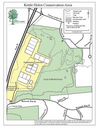
A multitude of looping side paths branch off the trail at Kettle Holes Conservation Area. If you choose to explore them, these many trails offer a good test of your wayfinding skills! For those looking for a straightforward hike, we recommend keeping to the main Moraine Trail, a 1.2-mile track marked by white blazes on trees. (Download trail map) The northern entry to Kettle Holes is on Research Road, between the Social Security Office and the end of Research Road. Small white arrows on the sidewalk mark the trailhead. The southern entry branches off the north side of Blacksmith Shop Road, just east of the service road intersection. Please stay on marked trails during your walk, particularly as you navigate around the wastewater treatment plant. If you’re hiking the nine-mile Falmouth Moraine Trail, you can continue south to Collins Woodlot by crossing Blacksmith Shop Road, directly across from the wastewater facility service road. Walking north from Kettle Holes, your next destination is the Northern Moraine Conservation Area. You'll find this entry on the north side of Thomas Landers Road.
Habitats & Wildlife
One of Kettle Holes Conservation Area’s most noticeable features is its strange trees. The skinny scrub oaks that grow here often have dramatic waves in their trunk, caused by high winds and competition for light as these trees grew. Dense woodlands alternate with clearings that fill with bright green ferns in the spring and summer. True to its name, the land at Kettle Holes Conservation Area contains several glacial kettle ponds. These water-filled depressions formed when chunks of ice broke off of glaciers and melted into the ground. You’ll pass by the largest kettle pond — now a plant-filled wetland that echoes with croaking frogs during warm months — about a quarter-mile from the Moraine Trail’s northern trailhead on Research Road.
Details & Amenities
Things to Do
Trail Maps
Image Gallery


Features
Kettle Holes Conservation Area sits on Falmouth’s glacial moraine, created during the last Ice Age. Glaciers sculpted these rolling hills and deposited massive boulders called erratics that you’ll find beside the trails. The paths at Kettle Holes Conservation Area traverse gentler hills than elsewhere on Falmouth’s glacial moraine, making this a good place for beginners to give hiking a try. Fall, winter, and early spring are particularly good times to hike at Kettle Holes: If you look west, you’ll sometimes glimpse the waters of Buzzards Bay between the bare trees in the distance!
Trails
A multitude of looping side paths branch off the trail at Kettle Holes Conservation Area. If you choose to explore them, these many trails offer a good test of your wayfinding skills! For those looking for a straightforward hike, we recommend keeping to the main Moraine Trail, a 1.2-mile track marked by white blazes on trees. (Download trail map) The northern entry to Kettle Holes is on Research Road, between the Social Security Office and the end of Research Road. Small white arrows on the sidewalk mark the trailhead. The southern entry branches off the north side of Blacksmith Shop Road, just east of the service road intersection. Please stay on marked trails during your walk, particularly as you navigate around the wastewater treatment plant. If you’re hiking the nine-mile Falmouth Moraine Trail, you can continue south to Collins Woodlot by crossing Blacksmith Shop Road, directly across from the wastewater facility service road. Walking north from Kettle Holes, your next destination is the Northern Moraine Conservation Area. You'll find this entry on the north side of Thomas Landers Road.
Habitats & Wildlife
One of Kettle Holes Conservation Area’s most noticeable features is its strange trees. The skinny scrub oaks that grow here often have dramatic waves in their trunk, caused by high winds and competition for light as these trees grew. Dense woodlands alternate with clearings that fill with bright green ferns in the spring and summer. True to its name, the land at Kettle Holes Conservation Area contains several glacial kettle ponds. These water-filled depressions formed when chunks of ice broke off of glaciers and melted into the ground. You’ll pass by the largest kettle pond — now a plant-filled wetland that echoes with croaking frogs during warm months — about a quarter-mile from the Moraine Trail’s northern trailhead on Research Road.